2015–16 Grants
Following are summaries of the research grants awarded:
“Illuminating the human dimension of coral reef management*”
Stuart Sandin, associate professor, Scripps Institute of Oceanography (SIO); and Jennifer Smith, associate professor, SIO
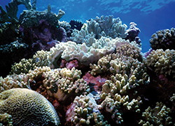
Stuart Sandin and Jennifer Smith literally are magnifying their multiyear efforts to monitor anthropogenic impacts on coral reefs surrounding 25 islands in the tropical Pacific. A challenge in the study of coral reef ecology across large regions is providing a reliable, consistent depiction of the geographic context of each reef. Through the use of high-resolution satellite imagery, Sandin and Smith will quantify metrics of human activity such as by measuring numbers and types of fishing boats; numbers and locations of boat landings, harbors and docks; and distances of fishing centers from reef habitats. Their end goal is to establish a regional scale perspective of coral reef health to quantify the natural variability that exists within reef communities and how humans alter these patterns across space and over time.
“A top-down view of social media users*”
Lev Manovich, director, Software Studies Initiative (SSI); and Mehrdad Yazdani, data scientist, SSI
Through the lens of high-resolution satellite imagery, Lev Manovich and Mehrdad Yazdani’s research project captures a snapshot of Instagram users on the ground. Their pilot project narrows in on a span of New York City where 10.5 million Instagram images were captured and shared. Factoring in U.S. Census indicators such as average income, education level and race composition aggregated for the same area, the researchers will examine variables relating to the visual and spatial environment around the geographical area. In cross-referencing the data gathered via satellite imagery (i.e., color characteristics and measures of geometric structure and density) with data extracted from the images (i.e., faces in a photo, tag and information about upload date, time and locations), the researchers hope to unveil new knowledge about society, culture, cities and/or people’s activities.
“Locating (solar-powered) cell towers*”
Orest Bucicovschki, postdoctoral researcher, Department of Mathematics; David Meyer, professor, Department of Mathematics; and
Dongjin Song, Ph.D. candidate, Department of Electrical and Computer Engineering
Mobile phone data sets increasingly are available for developing countries, supplying information such as call volumes between cell towers and approximate locations for the towers. However, they rarely include additional characteristics of the towers like whether or not they are connected to a power grid, supplied with a diesel generator or powered by a solar panel array. Orest Bucicovschki, David Meyer and Dongjin Song’s research project strives to develop algorithms to locate solar-powered cell towers using high-resolution satellite imagery and to integrate the results with existing mobile phone data sets. Among other applications, the researchers hope to explain local service interruptions and suggest technology policies for mitigating them.
“Satellite data for humanitarian assistance*”
Rex Douglas, postdoctoral researcher, Department of Mathematics; and Asif Shakeel, postdoctoral researcher, Department of Mathematics
Quick and accurate crisis assessment is critical to saving lives and allocating limited disaster response resources in the events of large scale human displacement, often the unexpected and sudden consequence of manmade and natural disasters. Rex Douglas and Asif Shakeel’s research project uses high-resolution satellite imagery to steadfastly identify and track refugee concentrations in both disaster relief and early warning scenarios, specifically detecting temporary shelters in places that are remote or dangerous for ground observers. The researchers also seek to develop and train a classifier for the automatic identification of temporary structures.
“Big Pixel Hackathon*”
Gordon Hanson, professor, GPS
CGT spearheaded its first-ever hackathon May 23, 2015 giving 35 students unprecedented access to DigitalGlobe Basecamp, the largest private collection of high-resolution satellite imagery on earth that comprises 15 year’s worth of millions of square kilometers of current and archived imagery. Master’s and Ph.D. candidates were tasked with defining an important policy question and then brainstorming how satellite imagery can be used to resolve it. The event gleaned insights into how to measure the growth of urban slums in poor countries and the impact of natural disasters on water quality in cities as well as how to identify illegal fishing in the Caribbean and how to find boats engaged in human trafficking in the Mediterranean.
“Applying satellite imagery to land degradation, groundwater resources and cityscapes*”
Jennifer Burney, assistant professor, GPS
Jennifer Burney has her hands in three research projects incorporating high-resolution satellite imagery. The first closely examines the physical structure of cities in an attempt to understand the actual economies of scale that emerge as cities form and grow. Through this effort, Burney aims to develop a database of several hundred cities as a prototype for this analysis. Burney also is assessing semi-arid ecosystems to develop density maps to be ground- truthed and linked to farm-level management data. Lastly, she seeks to alleviate the cost of geophysical surveys for community-based development of groundwater resources. Launching this project in sub-saharan Africa, she will use satellite imagery in lieu of ground-based resistive measurements to identify high-likelihood-of-success locations for new borewells.
“California and China Collaborating on Clean Energy and Combating Climate Change”
As the two largest emitters of greenhouse gases, the U.S. and China are facing the challenge of transforming fossil fuel–based energy systems into clean, 21st century energy systems that reduce emissions amid expanding economic opportunities. This new report from the Asia Society’s Center on U.S.-China Relations and Asia Society’s Northern California Center was drafted in partnership with The Annenberg Foundation Trust at Sunnylands and acts as a resource to learn about the vital partnerships already taking place between California and China on clean energy and to combat climate change. The report was made possible via funding from CGT, Rockefeller Brothers Fund, Energy Foundation, International Council on Clean Transportation and Energy and Environmental Economics.
*Supported by the Big Pixel Initiative, a technology partnership with DigitalGlobe Foundation made possible through funding from CGT and UC San Diego’s Qualcomm Institute.